• Welcome! The TrekBBS is the number one place to chat about Star Trek with like-minded fans.
    If you are not already a member then please register an account and join in the discussion!

Star Maps of the Great Powers/Coalition/Early Federation

Lord Hierarch

Commander
Red Shirt
Has there been maps that tried to show the political bounderies/known locations of the various space powers of these era's?

A long time ago I used a website called Solstation. Showed maps and even had a downloadable program to chart and plot stars.

Sadly went the way of Java and I have not found a program remotely like it.
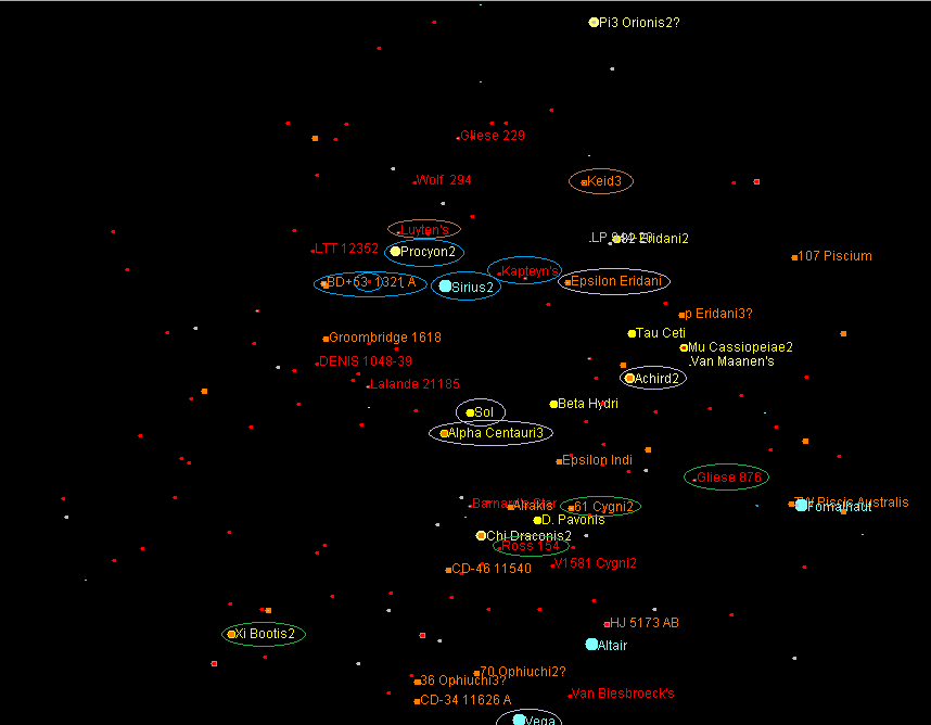
h_e_political_map_by_lord_hierarch-d5pqdhd.png


In this case:
Maroon is United Earth.
Blue is Andorian Empire.
Brown is the Vulcan Confederacy.
Green is Tellarite.
 
Last edited:
Hi

The map is confusing. And some of the text is difficult to read.

I assume your "legend" are the circles. What about the color of the text and stars. They don't seem to be consistent with the circles.And why do some stars have outlines while others don't?
 
Hi

The map is confusing. And some of the text is difficult to read.

I assume your "legend" are the circles. What about the color of the text and stars. They don't seem to be consistent with the circles.And why do some stars have outlines while others don't?
Below the map is the text.
 
Okay, so what are the circles, and stars...and why do some stars have outlines?
 
Okay, so what are the circles, and stars...and why do some stars have outlines?
The stars are stars and the circles are to indicate what race/civ claims them.

The color of the stars are the color of the stars. The program used star data to plot the stars and class.

The map was the closest 25 or 50 stars. From that I took a screenshot and added circles.
 
I think a map circa 2155 would be patchy at best, with a lot of dead space in between. its not clear how many worlds and systems fell under each power. Beta canon suggests a number of the powers listed below had several planets and systems under their thumb. But going by what has appear onscreen, there’s not much to go by.

United Earth – Sol

Human colonies – Vega, Deneva, Alpha Eridani II

Alpha Centauri Concordium – Proxima Colony

Confederacy of Vulcan – Vulcan

Andorian Empire – Andoria, Weytahn

United Planets of Tellar – Tellar, Babel

United Rigel Colonies - Rigel

Klingon Empire – Qo’noS, Narendra III, Rura Penthe, Qu'Vat colony

Romulan Star Empire - Romulus, Remus, Unroth III, Romii (presumably), Cheron (presumably)

Orion Syndicate – Verex, the Borderland

Tholian Assembly - Tholia

Xindi – Azati Prime, Xindi Council Planet, Xindi-Arboreal colony

Suliban - none (nomadic); unnamed gas giant (Cabal)

Kziniti Patriarchy - Kzin

Then there are the smaller powers: the Vissians, The Tanadarans, Coridan, the Nausicaans, the Xyrillians, the Denobulans

There are also unknown allegiances such as the planets in Sector 2158; supposedly human colonies circa TNG, but is also archeological site for the Romulans.

I would also like to add that there is a map circa 2161 on ditl.org, I'm not sure how accurate it is, due to its location of Cardassia; other star maps place Cardassia in a different location.
 
Last edited:
I wouldn't call them 'great powers', they're just the powers the Federation is in direct competition with. The Vissians, for example, may be a smaller spot on the map, but may be able to easily curb stomp everyone else on the map if they wanted to, being centuries in advance of all other species mentioned, and still being significantly ahead of what the 24th century Federation will have to offer, technology-wise.
 
Great Powers is what I use to describe the pre-Federation
I wouldn't call them 'great powers', they're just the powers the Federation is in direct competition with. The Vissians, for example, may be a smaller spot on the map, but may be able to easily curb stomp everyone else on the map if they wanted to, being centuries in advance of all other species mentioned, and still being significantly ahead of what the 24th century Federation will have to offer, technology-wise.
The title refers to 3 eras - 2151-2155, 2155-2160, and 2160-2XXX.

At least to me. The Great Powers are the term I use.

Edited OP to try and make a little clearer.
 
Its non-canon, but the Star Trek: The Beginning script indicated that the Coalition of Planets were made up of Earth, Vulcan, Andoria, Tellar, Rigel and Denobula circa 2159. Perhaps that would be an easier star map to make than a map of 2155.
 
given a lot of the official maps seen on screen were based on the starcharts book, it might be interesting see the known territories overlaid on said book's map. especially since it had details like some of the routes the NX-01 took, the former location of the expanse, etc.
 
I think that star maps book from 10 years ago (or whenever) showed the path
 
I've made my own attempt at a map before the Romulan War, in 2021, inspired by Starfleet Museum (who has a map and article here, from 2014) and Atomic Rockets; but I also found these maps (map) from Startrek Minutae's (map) take on the Romulan War (Map) from 2010. (Article)

It's really hard to showcase star altitudes and eccentricities on a 2d map. Atomic Rockets had a great one with just - and + numbers to them and their distance from our sun but that'll break down at any great length.... And more importantly, tying down real life star systems to trek is a whole new can of worms.

I was mostly inspired by just how SLOW warp is, so the scale of things is much smaller, even warp 9 is ridiculously slow to me. Alpha Centauri in a day, roughly? And the Federation is a hundred LY across with a hundred and twenty member worlds and thousands of stars? Speed makes politics possible, after all, and all these entities have terrible speed save for the borg/transwarp guys. By DS9 the Federation would barely be beyond the local bubble by my guess, though of course exploratory missions have gone a lot further, probes further still, and some alien worlds would join faster than others, warping the shape, while the Romulans and Klingons detest 'tendrils' and try to expand more evenly, and of course more 'attractive' systems either with class M worlds or with resources would be picked over boring red-star systems....

Not sure if I’m going colour blind.

I see:

Yellow
Orange
Red
Cyan

Not at all the colours you describe.

I do see a Green but I'd call 'brown' orange and 'maroon' red, much bright.
 
SolStation's java app was wonderful for the above reasons, you could rotate the map around and center it on different stars and adjust the distance seen on the map. Made things so easy using I think it was ISDB to plug in star data to add it to the map and then center it and see what stars were nearby to make into a colony or see what races could be in the vicinity and where territory branches off to.

Using the DITL calc, I used a ship traveling at warp 3 for 1 year non-stop to be the max distance UE could go. 27 LY. Drop it to Warp 2 for 1 year, that's just 8 years.

And then I remembered Conestga traveled ~20 light-years and I went, eh :p.

I do see a Green but I'd call 'brown' orange and 'maroon' red, much bright.
Personally I just tried to click on colors in Paint that would appear well on the map.

Not at all the colours you describe.
Is my blue your blue? Is my maroon your maroon? What we call a color might in fact be a spectrum of shades that we don't realize are all unique to oneself.


Or something :p.
 
If you are not already a member then please register an account and join in the discussion!

Sign up / Register


Back
Top