• Welcome! The TrekBBS is the number one place to chat about Star Trek with like-minded fans.
    If you are not already a member then please register an account and join in the discussion!

First look inside the new Stellar Cartography

8of5

Fleet Captain
Fleet Captain
Amazon has updated it's listing for Larry Nemecek's new book and maps set Star Trek Stellar Cartography with a look inside the clamshell, which gives a good sense as to how the collection will be presented, the first look at the cover of the actual book, and a few glimpses at some of the maps

Star+Trek+Stellar+Cartography+contents.jpg

Star+Trek+Stellar+Cartography+clamshell.jpg


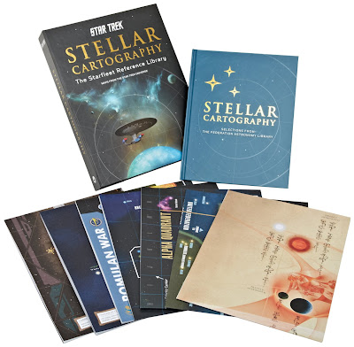
For some reason all the international Amazons have a set of seven images (which as ever I've posted on my site), while for now Amazon in the US just shows the top group photo I've posted above.

I'm REALLY looking forward to this one!
 
This does look really cool. It's nice to see them doing these kinds of high quality non-fic books, even if most of them are beyond my price range.
 
As both a geographer and a Trek fan, I am REALLY looking forward to this one. I already own Star Charts, but one can never have too much of a good thing.
 
I was curious if the space map on the left side of this graphic would have anything to do with the book. It seems not.

I'd like to see how the maps will compare to the Star Charts or the earlier Star Trek Maps.
 
I may have to get this for christmas, I love collecting art/production books. I wonder if any of those pull outs are frameable...
 
I fear that I will be disappointed. Clearly this is just updated Star Charts. Just notice the Romulan, Cardassian and Talarian states.
Also 48 pages vs 105.
And those extra maps like the Vulcan one, or Cardassian. :sigh: Nice, but no need for them.

By the way what map would we like to see? Political map of the Delta Quadrant? One that is in line with the novels? Or STO?


I was curious if the space map on the left side of this graphic would have anything to do with the book. It seems not.

I'd like to see how the maps will compare to the Star Charts or the earlier Star Trek Maps.

King, what is that nuTreky picture?
 
I was curious if the space map on the left side of this graphic would have anything to do with the book. It seems not.

I'd like to see how the maps will compare to the Star Charts or the earlier Star Trek Maps.

Me too.

I WANT this to be a valuable addition to my bookcase but I think I am going to have to reserve judgement until I see more of this.
 
Political map of the Delta Quadrant? One that is in line with the novels? Or STO?

I would presume that this product, even though being produced in boutique numbers, is still likely to be aimed at general audiences who like/watch "canonical" Star Trek, as were Bantam's "Star Trek Maps" and Simon & Schuster's "Star Trek Star Charts". It's the kind of thing that relatives will buy, for Christmas season gift-giving, for "the Star Trek fan who has everything". (And probably already has the item on their standing order, so they'll end up with two.)

Any references to the ongoing 24th century ST novels, or computer game tie-ins, would be minor. Like the in-joke references to places such as Ringworld, Altair IV, Edos and Cait, in the previous incarnations.

Political map of the Delta Quadrant? Surely, we really only know the areas along the path taken by Voyager as it traveled home? Anything else is going to be speculation, and then the subject of angry complaints if the new VOY novels fail to comply.

If I could have just one thing changed from Star Charts, it would be: move Andor further away from Earth than Procyon!

Why? Are we obscuring your view of Venus?
 
If I could have just one thing changed from Star Charts, it would be: move Andor further away from Earth than Procyon!

Why? Are we obscuring your view of Venus?

Because if Earth had colonized a planet nearly 20 light-years away decades earlier (Terra Nova), it's implausible that they would've known nothing about an advanced starfaring civilization around an even closer star -- a star even closer than Vulcan's.

It's a fair point about Procyon. Epsilon Indii wouldn't have been much of an improvement either.

I do wonder at how much political - and other - "steering" the Vulcan government could have really done about keeping Earth vessels away from Andorian holdings, regardless of the identity of Andor's homestar.
 
I'll wait and see untill a few shots of the maps themselves appear online as previews. It loos cool though.
 
The problem is that ENT itself gave mixed messages about Vulcan's location. The first season or two treated it as a fairly distant system, but then "Home" in season 4 locked it down as 16 light-years away -- the distance to 40 Eridani, the star that has generally been accepted as Vulcan's sun since James Blish first proposed it in his "Tomorrow is Yesterday" adaptation.

Although, come to think of it, Star Charts was made when ENT was only a year old, so it went with 40 Eri out of tradition.

It also made a mistake by putting Axanar and some other first-season systems as close to Earth as it did. Mandel erroneously thought that NX-01 went back to Earth after "Broken Bow," when in fact it just kept on going from Qo'noS. So the systems visited in the early episodes should've been much farther away. Although then you run into the problem with the location of Vulcan space and places like P'Jem.
 
I was curious if the space map on the left side of this graphic would have anything to do with the book. It seems not.

I'd like to see how the maps will compare to the Star Charts or the earlier Star Trek Maps.

King, what is that nuTreky picture?
It's the "powerwall" seen in the background of Pike and Marcus' offices in Into Darkness, cut together from the video here: http://vimeo.com/72019454

The non-annotated version and an early prototype are here.
 
It's the "powerwall" seen in the background of Pike and Marcus' offices in Into Darkness, cut together from the video here: http://vimeo.com/72019454

The non-annotated version and an early prototype are here.

Interesting, although a lot of the details clearly weren't meant to stand up to close analysis -- like the part on the far right with star system names superimposed on a satellite photo of the San Francisco Bay Area, or anachronistic references to "transwarp network" and "Orgainian [sic] Peace Treaty."
 
^Look closer, they each point to flights out of San Francisco to those worlds. And a transwarp network would explain the extremely fast travel times in the new movies, should one insist on using the warp factor cubed formula as a baseline.

That said, you're right it was only ever intended to be background art. But a piece of background art I've had a great deal of fun analysing. Trek referencing Trek is nice after Mike Okuda's endless non-Trek references in TNG screengraphics.
 
And a transwarp network would explain the extremely fast travel times in the new movies, should one insist on using the warp factor cubed formula as a baseline.

Why should we insist on that, when TOS itself never did? The one episode that gave us a direct warp factor/distance/travel time comparison was "That Which Survives," and the warp velocity it indicated was thousands of times greater than what the WF-cubed formula would suggest. That "formula" was a myth to begin with.

Besides, nothing we see in the films is consistent with a "network" of transwarp lanes. Ships just go really, really fast from any given point to any other given point.
 
Oh, I agree completely. It's just some people in XI+ are somewhat fixated upon it, and I wonder if whoever made that graphic snuck it is as a possible "out" for them.

It's also possible it refers to transwarp radio, as described in Mr. Scott's Guide to the Enterprise (which is where they got the "diburnium-osmium" shields from) and which might explain (again, should one need an explaination) Kirk's phonecall from the Klingon border to a club in San Francisco.
 
If you are not already a member then please register an account and join in the discussion!

Sign up / Register


Back
Top