• Welcome! The TrekBBS is the number one place to chat about Star Trek with like-minded fans.
    If you are not already a member then please register an account and join in the discussion!

Mapping Mondas

David cgc

Admiral
Premium Member
When we saw Mondas on the computer screen in "World Enough and Time," it was updated from its old, "Earth, but upside-down" appearance from the classic series, and had a number of minor differences from Earth added. I'd been hoping the complete map would be released on the BBC's concept art page for the episode, but no such luck. I unwrapped what we saw into a map. My blog has a comparison with Earth that makes it easier to see the differences and more details, but here's what we saw of Mondas:


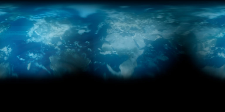
Some of the most notable differences are that India has been moved to South America, Madagascar has been moved to the Pacific ocean, Africa has a giant gulf in the middle of it, and both Africa and North America have large straits cutting them in two. Europe seems to be the only part of the globe that was left untouched.
 
It kinda looks like the map of the Alternate Earth in 'Stephen Universe'.

Big hole in Siberia, add-ons to South America, big chucks of Africa missing
 
Alaska looks to me like it's detached from North America.

I'm not sure what happened with the Colorado River to make it that wide. (The strait through North America looks to me like it's where the Colorado is today.)

What you think is Australia could be New Zealand. That sounds weird, so let me explain -- New Zealand is a sunken continent, and the islands are all that remain above the Pacific's surface. Perhaps New Zealand didn't sink, and it collided with Australia to create a larger continent.

I'm not seeing India with South America. I do see that South America is misshapen quite a bit, but none of it is screaming India to me.

I can't think of any way that Africa would look like that. Plus, an Africa that radically altered would have had direct effects on human evolution due to different conditions and different habitats.

All of that said... good work! :)
 
What you think is Australia could be New Zealand. That sounds weird, so let me explain -- New Zealand is a sunken continent, and the islands are all that remain above the Pacific's surface. Perhaps New Zealand didn't sink, and it collided with Australia to create a larger continent.

Zealandia

It's hard to see what's happening I got the Southern Hemisphere.
 
I'm not seeing India with South America. I do see that South America is misshapen quite a bit, but none of it is screaming India to me.

It's subtle, I probably wouldn't have noticed if I hadn't seen India was missing first. India's west coast has a little kink in it, like a very wide "V" shape, and you can see that same wide "V" on the northwest part added to South America (though India isn't large enough to account for all the new land you can see).

Zealandia is an interesting theory to account for what's going on in the Australia area. Most of the changes look like they were straightforward Photoshop work (all the new land seemed to come from somewhere else on the globe, like the islands splitting off Alaska are just the ones that are north of Canada moved over a bit), but painting a whole continent from scratch doesn't seem to fit with the style of what we can see. My first instinct when I saw it was that Antarctica had been moved up (probably because that's something Caprica did), but the shape is different, and it wouldn't have been as easy to do by simply painting over the map (though it wouldn't have been that hard). Maybe that was the most elaborately retouched part of the globe, and it wasn't as convincing or recognizable, and that's why we don't see that angle.
 
If you are not already a member then please register an account and join in the discussion!

Sign up / Register


Back
Top