http://i113.photobucket.com/albums/n227/emistal/mapplates-1.jpg
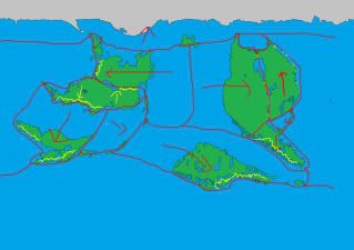
As you can see I got rid of the archipelago connecting continents 1 and 4.
I need to change some things around too. I think I will move the island in the northeast (marked ?) to the convergence points of continents 1, 4 and 7.
I also have to move and rotate some of the continents to take into account their direction of drift.
Yes I prefer your new plates.
")
They look more realistic, although continent 5 still looks a bit squashed in. Perhaps extend that red line on the lower right side of plate 5 to continue upward at a similar angle so that plate 5 includes a triangle of ocean. I think then it would look better.
The island you want to move -- maybe. I think it would look fine in either place. It depends on what you want the island to be. Where it is now looks kind of mysterious, but at 1-4-7 it would be an obvious strategic location. And yes, lying on a fault line it would more likely be a volcanic island, and possibly still active? , so any lore associated with it can revolve around that .
I'm noticing 1 and 2 are diverging, so that region to the right of the great lake isn't going to be mountains -- more like the lake will be growing.
If you make island 5 move up instead of right, it will allow 4 and 5 to grind against each other, which is ideal quake territory, and maybe useful in the lore for island 5 -- you can happily imagine the native inhabitants of 4 will think of the land of 5 to be the domain of evil gods because of the regular quakes along that fault line.
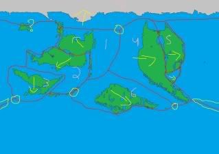
Island 6 looks cold and bleak. Island 3 looks the most interesting for some reason. I imagine that having the most temperate climate on the map, and supporting the most advanced civilisation.
Island 2 looks warm continental and some tropical areas, while island 1 looks cool continental. None of these islands come across as being desert-like... maybe the middle of 4 is the best candidate ?
Good work. I look forward to seeing some terrain and climate details.
 This is definitely better, although I wasn't really complaining; the number and size of giant lakes seems unlikely, but unlikely things do happen. There's no reason that a planet couldn't look like this, especially if the ice age had been in the very recent past.


")