Utility of Trek's Star Map Graphics

Discussion in 'Trek Tech' started by FalTorPan, Mar 1, 2008.

  1. FalTorPan

    FalTorPan Vice Admiral Admiral

    Joined:
    Jan 25, 2000
    Location:
    Out there... thataway.
    I'm as much a fan of Okudagrams and works like Geoffrey Mandel's Star Trek Star Charts as anyone. Having said that, how useful would the sorts of displays that we've seen in Trek shows, films and books be to people of the Star Trek universe? At best, these displays are two-dimensional projections. Ignoring that most of Trek's space scenes are very two-dimensional in nature, space is very three-dimensional. Given that, how useful is a single, two-dimensional diagram?

    The various Trek maps that have been published over the years have the same problem. What good is a "plan view" of the galaxy without information about the third dimension?
     
  2. AstroSmurf

    AstroSmurf Vice Admiral Admiral

    Joined:
    Apr 23, 2006
    Location:
    Over the Blue Moon
    Over the years, this has been something I have complained about as well. Without that third dimension, these "collasped" views are about as useful as riding a horse without the horse. You may have good intentions but you would get very far.

    But all kidding aside, these two dimensional views do not accurately show the distance or location of a celestial body. The 2D map shows all these worlds crammed on top of one another when in reality, these planets may not even be close to each other but appear to be because of line of sight. These maps also tend to leave out important features for the sake of clarity. For example, I have heard so many people complain about the fact that the Enterprise could never have reached the edge of the galaxy in "Where No Man Has Gone Before" without having to travel a very long time. However, people always forget there are two more "edges" that could be crossed, above and below. Both could be reached within a decent amount of time and still be within the confines of the Federation. But since people can't see those "edges", they forget they even exist and automatically think the episode is talking about the rim.

    I also understand how difficult it would be to portray the depth of these maps on a television budget. Now if the were to consistently portray the galaxy as they did in "Generations" (Stellar Cartography), than I think the audience would have a much better understanding of navigating three dimensional space.
     
  3. Christopher

    Christopher Writer Admiral

    Joined:
    Mar 15, 2001
    But one reason why they use 2-D maps on the shows and in the Star Charts book is precisely because they don't convey precise information, which leaves wiggle room for the creative staff. If they showed too clearly that Planet X was close to Planet Y and a story came along that required Planet Y to be a considerable distance away, it would be too restrictive. Stardates serve the same purpose -- the less information is actually conveyed, the more flexibility it affords the storytellers.

    It helps to accept these things as storytelling conceits that are merely placeholders for what would "really" be used if this were actually happening. For instance, pretend that the 2D charts that get flashed on the screens can easily be rotated to give a 3D perspective if needed.
     
  4. Harry

    Harry Captain Captain

    Joined:
    Feb 29, 2000
    Maybe this is related to why Starfleet people can apparently make sense of screens full of random numbers and blinking lights. Besides probably being able to rotate into a full-3D map, there is some sort of non-obvious way to telling distances from those maps from the random numbers on another screen. Maybe like how a London Underground map may be confusing and not representative of the actual layout of a city, if you didn't know what it was about.
     
  5. FalTorPan

    FalTorPan Vice Admiral Admiral

    Joined:
    Jan 25, 2000
    Location:
    Out there... thataway.
    On the shows, I imagine that the graphics are 2D because most TV viewers don't think in three dimensions. As far as any publication featuring star maps is concerned, if its authors were actively trying to be vague about positional information -- and I question that assumption -- then the book has no useful purpose. All reference books risk becoming obsolete.
     
  6. Hofner

    Hofner Commodore Commodore

    Joined:
    May 8, 2003
    Location:
    Charlotte, NC
    How useful are the 2-d charts? I'd think not much. If you mean for navigation they wouldn't use maps at all. Ultimately, you'd have a computer crunch the numbers and give a direction to go.

    For just getting an idea of the relative positions as you said, you need that third dimension. Like Christopher said, they should be able to rotate those 2-d displays to get an idea; it's easy enough for a computer to do this.

    About seven years ago I ran across this nifty little program that showed all the stars within 50 lightyears or so. You could rotate it around in 3-d by using the mouse. I haven't kept up with there kind of programs since then, I don't know what's out there these days.

    Robert
     
  7. FalTorPan

    FalTorPan Vice Admiral Admiral

    Joined:
    Jan 25, 2000
    Location:
    Out there... thataway.
    Even two 2D diagrams -- say a "top view" and a "side view" -- wouldn't be of much use when figuring out which regions of space are UFP-controlled, Romulan-controlled, etc., since those regions of space are "blobby."
     
  8. Timo

    Timo Fleet Admiral Admiral

    Joined:
    Aug 26, 2003
    Most of the maps we see portray vast swaths of space, with dozens of squares of 20/20 ly grids - or then individual solar systems and their neighboring systems.

    In the former case, the view is probably locked into the orientation of a universal grid system, and we might thus be missing crucial information about the third dimension. In the latter case, though, the map might be rotated to eliminate the need for the third dimension. After all, you need three dimensions only if you have four points of interest or more - and most plots only concern two or at most three spatial points. Indeed, the third dimension would be needlessly confusing in those cases.

    And actually, those maps showing dozens of 20/20 squares are relatively rare. In TNG and VOY, we see larger galactic maps where giant cubes, perhaps hundreds of ly on a side, are seen from an angle. It would be fairly meaningless to use those maps for figuring out the exact 3D distances between any two stars. Yet even a single layer of such cubes would be a nice way to approximately represent the relative locations of interstellar empires, which is what these maps are usually used for.

    Timo Saloniemi
     
  9. B.J.

    B.J. Rear Admiral Rear Admiral

    Joined:
    Jul 14, 2004
    Location:
    Huntsville, AL
    Celestia is a very cool and free program that you can navigate around our solar system and galaxy in 3D. I'd imagine that a real starship would use something very similar for a mapping program.
     
  10. Ronald Held

    Ronald Held Vice Admiral Admiral

    Joined:
    Feb 21, 2005
    Location:
    On the USS Sovereign
    How about a holographic display when you need to see in three dimensions?
     
  11. Masao

    Masao Commodore Commodore

    Joined:
    Apr 26, 2001
    Location:
    Tokyo
    I've experimented with colors to indicate the z dimension. Here I've used colors for a map of habitable systems and transit routes 20 ly around Earth (using old fandom locations). This approach works for limited areas of space, but if you have too many stars, it quickly become very messy (I know).
    [​IMG]
     
  12. JoeZhang

    JoeZhang Vice Admiral Admiral

    Joined:
    Jan 9, 2008

    and they have a trek add-on :thumbsup: I guess it adds shipyards and spacestations?
     
  13. EliyahuQeoni

    EliyahuQeoni Commodore Commodore

    Joined:
    Dec 24, 2007
    Location:
    Redmond, Oregon, United States of America
    Wow! very cool! Thanks for pointing that out :)
     
  14. Christopher

    Christopher Writer Admiral

    Joined:
    Mar 15, 2001
    That's taking the graphics too literally. Remember, these graphics aren't created with the intention that viewers will actually be able to read them in detail. All that's needed is to give the impression that there's something written there, but instead of going to the trouble of writing it, TV/movie graphic illustrators often just throw in random text. For fake newspapers and books, there's this passage of Latin text that's been routinely used for decades as that kind of fill-in material in all sorts of shows, movies, comic books, etc. On Trek, they use random numbers instead. But it's logical to assume that in the "reality" of the Trek universe, the buttons and charts have meaningful written text.

    On the contrary. I've read that Geoffrey Mandel deliberately kept 3D information vague in his Star Trek Star Charts book in order to give readers (and novelists) flexibility to interpret his maps as they desired. It's not true that a book has no useful purpose unless it defines everything with rigid precision. On the contrary: the purpose of a book like Star Charts or any fictional, in-universe "reference book" is to fire the imagination of the readers, to give them fodder for their creativity to build on -- not to pre-empt their creativity and spoonfeed them all the answers.

    Was that program ChView, perchance? If so, in addition to the 50-ly catalog, it also has star-position data files out to 250 ly.

    Celestia is a much more sophisticated program, but I still find ChView useful for my purposes, since it was specifically designed for mapping SF universes and thus allows you to add custom labels to star systems and draw "route" lines connecting them, something that can't be done (at least not easily) in Celestia. I have come across a more advanced program that seems to do the same thing, but it isn't free: http://www.nbos.com/products/astro/astro.htm
     
  15. Hofner

    Hofner Commodore Commodore

    Joined:
    May 8, 2003
    Location:
    Charlotte, NC
    @Christopher

    Actually there was a number of programs I was playing with. The program I was thinking of is not ChView but yeah that's one of the other software I experimented with. The reason I haven't played with this stuff for some time is because my vision's worse and it's hard for me to see these programs.

    I have trouble with Celestia fro example because my screen magnification program doesn't work with it.

    Anyways, here's the website where I found these programs:

    http://www.projectrho.com/starmap.html

    I'm not sure how up-to-date this site is. Last I checked some of the old software links didn't work including the one for the program I was thinking of. But as y'all can see Celestia and ChView is in there.

    Robert
     
  16. Christopher

    Christopher Writer Admiral

    Joined:
    Mar 15, 2001
    ^^Yep, that's where I found out about them too.
     
  17. FalTorPan

    FalTorPan Vice Admiral Admiral

    Joined:
    Jan 25, 2000
    Location:
    Out there... thataway.
    As I reread this thread, I've found that my comments seem harsh when they weren't meant to be.

    The various 2D star map graphics that we've seen over the years are by no means "useless" -- they just don't tell the whole story. I wouldn't presume to think that the people who make them think that a single 2D diagram is a complete description of whatever region it depicts.

    On the subject of Geoffrey Mandel's Star Trek Star Charts book, I love the thing. I bought my copy shortly after it first appeared at brick-and-mortar bookstores, and I still flip through it about once a week.

    I just hope that future publications and future Trek TV shows and films provide more three-dimensional glimpses of the Trek universe. :)
     
  18. Tiberius1701

    Tiberius1701 Fleet Captain Fleet Captain

    Joined:
    Sep 18, 2003
    I work with 3D modeling programs all the time. I have no problem interpreting odd three dimensional shapes and positions while working with them on my 2D computer monitor - no hologram needed.

    You know what? If I were to take one of those shapes and go to the 'top view', or even some other view, and all you saw was that view, then it might look like the image were only 2D.

    How do we know when they show a 2D graphic, that if the crew wanted to, they couldn't grab it and rotate it at will? In fact, we've seen some things like this from time to time, so I think that's pretty much the assumption we should make. It's a 2D screen with a 3D image on it that can be rotated, but often isn't rotated for the short periods we see many of them.

    As for the main view screen up front, it really is intended to be a holographic image with depth. That's why when they show it from the side it isn't foreshortened, but instead we see the person on the screen looking at Picard instead of at us like you would on a television screen.
     
  19. FalTorPan

    FalTorPan Vice Admiral Admiral

    Joined:
    Jan 25, 2000
    Location:
    Out there... thataway.
    I think most of us can say that. Most photographs, blueprints, sketches and paintings of real-world objects are 2D renditions of 3D things.

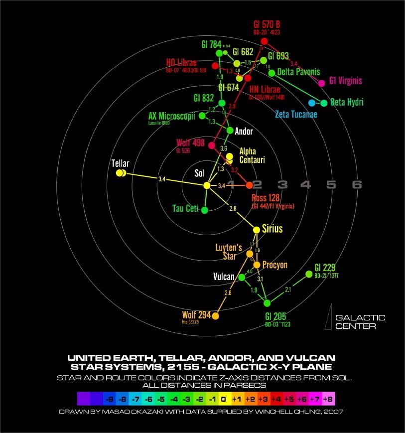
    Having said that, a single 2D star map can still be misleading. Imagine a star map with just three stars:

    [​IMG]

    First, the obvious -- I think we can all agree that it's unlikely that the three stars occupy the same "vertical plane" if being viewed from an arbitrary angle. If this is the only information that we're given, then how useful is the star map? Which two stars are closest together? We don't know. Which two stars are the farthest part? We don't know.

    Now assume we know that delta Burke and gamma Rae both lie within Federation space. Does beta Carotene lie within Federation space? We don't know. It might be in Klingon space. This might seem wrong, though -- after all, beta Carotene is between the other two stars -- or is it? We don't know.

    To people who don't know better, (1) beta Carotene lies between delta Burke and gamma Rae, (2) if delta Burke and gamma Rae lie within Federation space, then beta Carotene likely does, too, and (3) delta Burke and beta Carotene are the two stars which are closest together.

    To people who do know better, the above three observations might be made on an instinctive level based on what we see in the diagram. Of course, those assumptions might all turn out to be false. Either way, to people who do know better, how useful is the diagram by itself? I would argue that it has little value -- unless it can in fact be rotated, etc., as you've suggested.
     
    Last edited: Apr 9, 2008
  20. Timo

    Timo Fleet Admiral Admiral

    Joined:
    Aug 26, 2003
    ...Of course, with just three objects of interest on the map, we could assume it is always rotated so that those three lie on the same plane (and background grids be damned). The orientation of the viewing plane against some fixed grid like galactic plane would in general not be of much interest anyway. And since when have we seen Okudagram star charts with more than three actual points of interest?

    We do sometimes get three-dee views, such as in "Behind the Lines" where the mission of Dax is outlined by having a cubic grid drawn in cavalier perspective, the stars placed within, and each star connected to the bottom of the grid by a vertical line. But that particular view already seemed needlessly complex when the mission only involved flying there and back...

    Timo Saloniemi