So there I was, doing a little bit of the ol' research for my own fan fiction using Celestia and the nice giant maps of Star Trek: Stellar Cartography, identifying the key worlds and marking them in Celestia. Being curious about where Romulus might hypothetically be, I did another internet search and saw "128 Trianguli". Ok, good. Switched over to Celestia--it did not have a listing for 128 Tri, but no problem if it's a fictional star in the constellation--and found the constellation Triangulum, which is the northern sky. Problem is, it's on the opposite side of the sun from where the Romulan Star Empire is presented in the most current Star Trek maps. However, Triangulum Australe, the Southern Triangle, happens to be in the correct portion of the sky to correlate with the Romulan Empire. And beta TrA is an F1 V star about 40 ly away. If it is not a better candidate, some other star in the constellation will do.
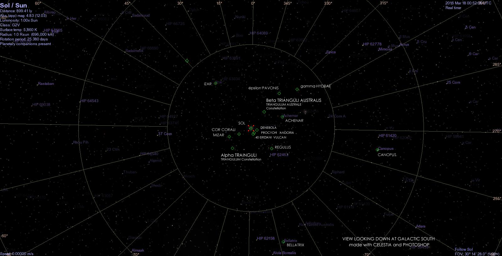
The stars marked in green diamonds represent the key stars of the Federation's core and outer ranges. Denebola probably isn't Denobula, but it's included as reference because both real and fictional stars are near the Romulan Neutral Zone. Because Celestia doesn't have a 128 Trianguli listed, I used alpha Trianguli instead as a reference to where the constellation would be, though it should be noted that the "territory" of the constellation extends along a direct line of sight from the Earth, however it would be unreasonable for Romulus to be outside the neighborhood of nearest stars. And it's obviously in the wrong place. Is my map upside down? No. Every other star matches position in reference to the official published maps, which I assume most of you have access to, or are familiar enough with them, so I don't have to find online sources to link, or attempt to photograph or scan and piece together sections of 24 x 36 inch posters.
The Klingons are outward past Regulus, Cardassia, Bajor, and DS9 are beyond Mizar, and the Ferengi and the Breen are near Izar.
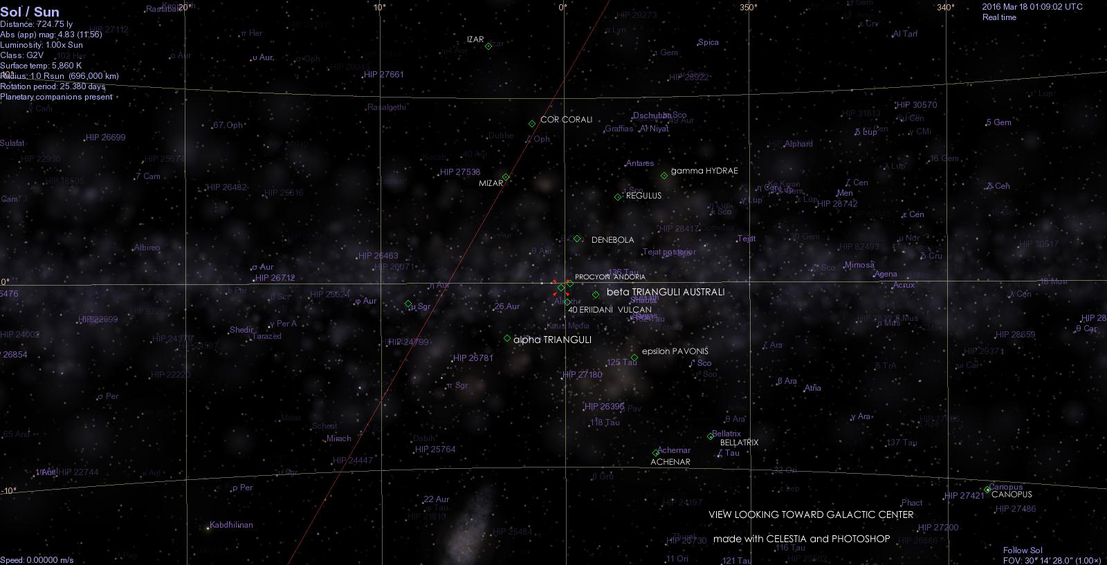
And here is a view looking toward the galactic center in Sagittarius. Achernar (misspelled in my maps) could be beneath the Romulan Star Empire as opposed to being in the middle of it. The arm of the Federation that extends to Canopus could also run under the Klingon Empire. Izar is pretty high above the galactic plane with lots of space underneath to explore between Kirk and Picard. And the Genesis dwarf planet is well beyond Bellatrix, meaning it would have taken the Reliant and the Enterprise several years at warp 7 to reach Ceti Alpha and the Regulas station. (Somebody need to recalibrate that warp speed scale!)
So anyway, if we want the Romulan empire between the Federation and the Delta Quadrant, Romulus can't be in The Triangle, it has to be in The Southern Triangle. Don't argue. Don't explain it away. Just thank me.
http://www.shatters.net/celestia/ Unfortunately, this software has not been updated since 2010. Celestia does no calculations, it presents planets and celestial objects, this is important to know because it is rather easy to create add-on systems, but if you know nothing of orbital mechanics, it will not care if you create impossible solar systems. It's limited in range, so when I wanted to create worlds for my own fiction some 33,000 ly away, I had/have to create everything, that's when excel comes in handy. http://scifiendvrs.blogspot.com/2012/08/making-new-solar-systems-for-celestia.html
The stars marked in green diamonds represent the key stars of the Federation's core and outer ranges. Denebola probably isn't Denobula, but it's included as reference because both real and fictional stars are near the Romulan Neutral Zone. Because Celestia doesn't have a 128 Trianguli listed, I used alpha Trianguli instead as a reference to where the constellation would be, though it should be noted that the "territory" of the constellation extends along a direct line of sight from the Earth, however it would be unreasonable for Romulus to be outside the neighborhood of nearest stars. And it's obviously in the wrong place. Is my map upside down? No. Every other star matches position in reference to the official published maps, which I assume most of you have access to, or are familiar enough with them, so I don't have to find online sources to link, or attempt to photograph or scan and piece together sections of 24 x 36 inch posters.
The Klingons are outward past Regulus, Cardassia, Bajor, and DS9 are beyond Mizar, and the Ferengi and the Breen are near Izar.
And here is a view looking toward the galactic center in Sagittarius. Achernar (misspelled in my maps) could be beneath the Romulan Star Empire as opposed to being in the middle of it. The arm of the Federation that extends to Canopus could also run under the Klingon Empire. Izar is pretty high above the galactic plane with lots of space underneath to explore between Kirk and Picard. And the Genesis dwarf planet is well beyond Bellatrix, meaning it would have taken the Reliant and the Enterprise several years at warp 7 to reach Ceti Alpha and the Regulas station. (Somebody need to recalibrate that warp speed scale!)
So anyway, if we want the Romulan empire between the Federation and the Delta Quadrant, Romulus can't be in The Triangle, it has to be in The Southern Triangle. Don't argue. Don't explain it away. Just thank me.
http://www.shatters.net/celestia/ Unfortunately, this software has not been updated since 2010. Celestia does no calculations, it presents planets and celestial objects, this is important to know because it is rather easy to create add-on systems, but if you know nothing of orbital mechanics, it will not care if you create impossible solar systems. It's limited in range, so when I wanted to create worlds for my own fiction some 33,000 ly away, I had/have to create everything, that's when excel comes in handy. http://scifiendvrs.blogspot.com/2012/08/making-new-solar-systems-for-celestia.html
