• Welcome! The TrekBBS is the number one place to chat about Star Trek with like-minded fans.
    If you are not already a member then please register an account and join in the discussion!

Boredom + MS Paint = this. Work in progress

What's his face

Rear Admiral
Rear Admiral
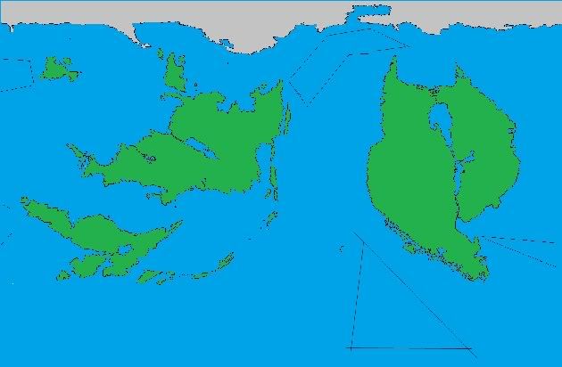
The thread I posted in Sci Fi & Fantasy about fiction set on non-earth planets got an idea into my head when I was bored. I went into paint and this popped out. It's not done yet, obviously. There's no terrain variation at all yet (elevation, climate, rivers etc) and the continent on the right isn't anywhere near done. The lines means I have to draw stuff in there still.

I'm trying to make it as "realistic" as possible, ie plate tectonics work out so the continents fit together, etc.

I thought I could make this a group activity. If you have any suggestions post them here. Is one continent too funny looking? is an island in the wrong place?

I also need to name the planet and the landmasses. If you have a good name let's hear it.
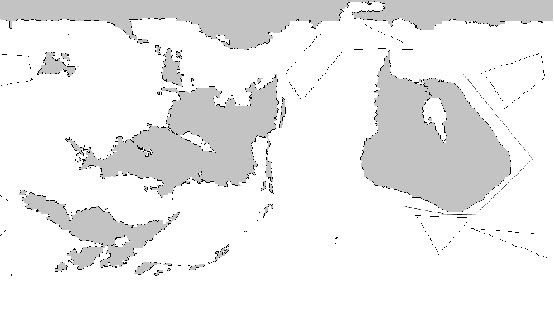
A larger size image is here:
http://i113.photobucket.com/albums/n227/emistal/map.jpg though the one I am drawing is 1594 x 1096
mapthumb.jpg
 
I haven't coloured it yet. The grey is land and the white is water.

I like designing worlds. :)

The land mass on the right looks too smooth. Add some peninsulas and estuaries. Also, make that river into a huge river delta, maybe? Perhaps the South Eastern side of it could be broken up a little, like Norway.

As for a name... Q'andra ?
 
Good ideas.

Yeah that continent isn't done yet. What I did for the other ones is draw a general shape first, then make it more complicated. The lines indicate there's stuff to do still.

It's a good idea to make it more like Norway, with the broken terrain on the south side, as that's where glaciers come from in this world (there's a continent in the arctic rather than antarctic pole here). The lower left continent would look well doing the same thing.

Is there any decent world generating software out there? I did a google search and most of the stuff seemed to be based on fractal patterns, which look rather artificial.
 
New update. I've filled out the western continent - and split it into two subcontinents.

Also I recoloured the land and water so there is no more confusion :p (Though the colours are temporary. I plan to make a climate map and put in deserts, rivers jungles, mountains, etc.)

The people who live on this planet are humans who live in a 21st Century culture like us. They drive cars and talk on cell phones and go to work. The most advanced countries are maybe 20-30 years ahead of us at most.

I think the names should reflect that this is a culture similar to our own. Maybe a mix of Greek and Roman sounding names?

Oh, and the black lines are placeholders for archipelago I haven't put in yet.

Here's the update:
larger image : http://i113.photobucket.com/albums/n227/emistal/map-1.jpg
mapthumb-1.jpg
 
I see two cats kissing :lol:

Very good What's his face :)

I don't know of any world generating software no. But you can use things like a fractal terrain generator coupled with your drawn maps to create a 3D surface. (This would also raise small islands up in shallow water and make the coastline more rugged)

You can also use similar routines to generate textures like grass and maybe forest density (which can be used to space out individual tree models).
 
Last edited:
I think it's a nice design; that's a very realistic-looking distribution of landmasses.

About fifteen years ago, I used to have a program called SimEarth that could be used to design planets; it even simulated climate and weather. I don't know if it, or something similar, is still available.
 
I think it's a nice design; that's a very realistic-looking distribution of landmasses.

About fifteen years ago, I used to have a program called SimEarth that could be used to design planets; it even simulated climate and weather. I don't know if it, or something similar, is still available.

Ahh SimEarth. Memories.
 
I would highly recommend getting yourself photoshop to continue with this project. It makes it much easier IMO. I did THIS a while back using lots of layer effects so that all I had to do was make the shapes and all the colors and lines were automatically drawn in for me.
 
I think it's a nice design; that's a very realistic-looking distribution of landmasses.

About fifteen years ago, I used to have a program called SimEarth that could be used to design planets; it even simulated climate and weather. I don't know if it, or something similar, is still available.
I remember SimEarth. Maybe what I'll do is find an old abandonware site that has it and download it. I'll make a map that sort of resembles what I've drawn and see where the different climates show up.

I would highly recommend getting yourself photoshop to continue with this project. It makes it much easier IMO. I did THIS a while back using lots of layer effects so that all I had to do was make the shapes and all the colors and lines were automatically drawn in for me.
Very impressive. I actually plan to go into photoshop when I'm done this basic outline and draw political and physical maps, and maybe even a bump map so I can put this thing into 3DS. It'll take a bit of learning though as I'm new to it.
 
Apparently, you can still buy SimEarth from Amazon (or an independent seller at Amazon). I think I'll get it.
 
I think there should be a mountain range between the inland sea and the eastern coast on that northwestern continent.
 
I think there should be a mountain range between the inland sea and the eastern coast on that northwestern continent.
I was thinking the same thing. If you look at that region you'll see it looks like two tectonic plates right up against each other. This of course means that there will be mountains and valleys in the the region where the two plates touch.

A question for everyone else: where should I put major features like mountains, rivers, maybe more lakes or inland seas?
 
If you are not already a member then please register an account and join in the discussion!

Sign up / Register


Back
Top