It is my vague understanding that the Sol System straddles the borders of the Alpha and Beta Quadrants because the delineation is a humanity-centric concept. (Stop me here if I’m already mistaken.
This has never been stated in any dialogue, so those who don't put much weight on background art can already call it a day here and say that the A/B border is at an undisclosed location.
The old
Chronology/
Encyclopedia books reveal that the authors felt the reference to "only ship in the quadrant" in The Motion Picture would best be covered by saying that there are two quadrants to choose from (the four big ones having already been established at that point) with the heroes being on one while all the rest of Starfleet supposedly was on the other. This never made an ounce of sense to me - especially considering that both TOS and early TNG made constant reference to "quadrants" that apparently were smaller sub-units of "sectors" and thus really intimate volumes of space, easily allowing for one starship per quadrant.
OTOH, the offscreen map books mentioned above all had the A/B line going through Earth, much like the Greenwich line goes through London. And those maps were used for background art in various Trek episodes and movies, sometimes in sharp focus. It's just that no map ever had the holy trinity of a) A/B line marked, b) camera pointing at that part of the map, c) focus...
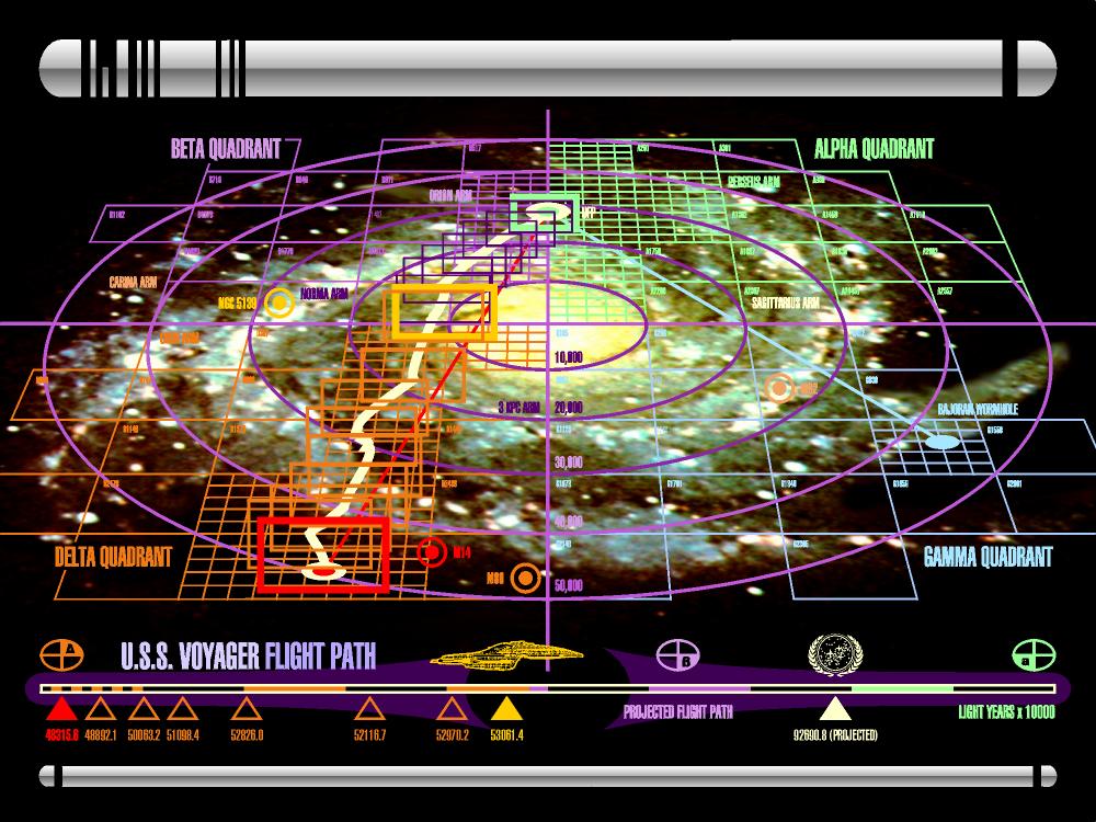
Now enter Discovery, and its war maps of the first season. Those are the very first to include a clearly marked A/B quadrant line, and it does
not go through Earth. No, that map does not actually show Earth - but it shows all the other
Star Charts highlights in the neighborhood, the real and fictional stars, and establishes that the A/B line is "actually" to the right, or widdershins, of Earth. Absent any other evidence, this is what we might just as well believe in, from now on and retroactively. It's not as if it would be in contradiction of any pseudo-fact we've heard or seen.
Now, while I do recognize that space is far from two-dimensional and the z-axis is of significant importance,
WRT this, it might be relevant to mention that Earth sits basically at the centerplane of the galactic disk as far as we can tell. That is, conventional wisdom has it at mere 50 lightyears above the plane that goes through the galactic core and best matches the spin of the whole. Milky Way isn't quite flat, but it is
surprisingly flat out here: there are stars "above" and "below" Earth, but only for a couple of thousand lightyears till they thin out to nothing. So maps drawn in 2D, looking "down" on Earth and its surroundings, are really surprisingly useful for scifi purposes.
am I correct in my analysis that the vast majority of Federation space is thus “to the left/west” (I know, I know) of Earth, because it’s in the Alpha Quadrant?
No onscreen map has showed the entire Federation in any easily discernible fashion yet, so we can argue either way. Certainly there's stuff in Alpha, and then stuff in Beta (such as Vulcan, if we accept it orbits the real star 40 Eri A which is there for real).
It’s strange to me that Starfleet’s expansion would tilt so thoroughly in one direction. But I get it — Star Trek is a fantasy universe and there are plenty of historic examples of countries following similar suit, besides.
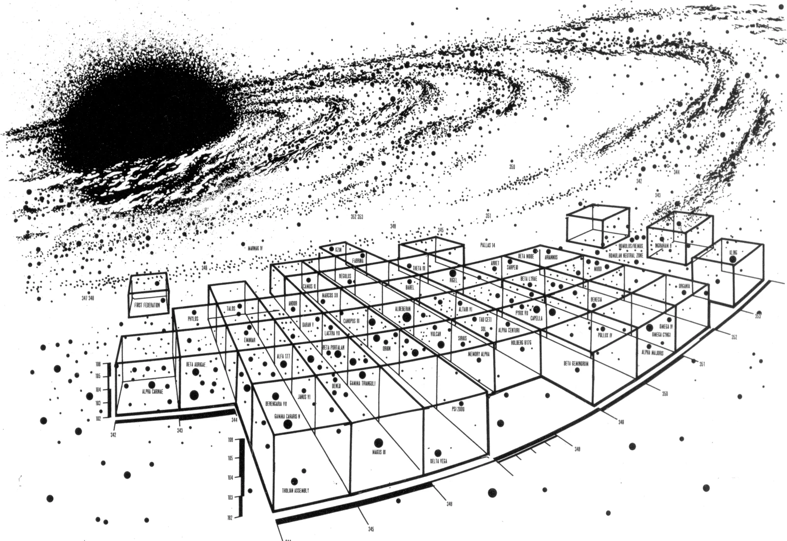
The idea in making
Star Charts and its derivatives was that the UFP has
not expanded in any direction particularly much. It's a small star empire, only a couple of hundred lightyears across, and has encountered enemies in every direction, thus failing to expand much.
However, unlike other star empires out there, the Federation isn't shy to invite in folks who are poorly situated strategically. The Romulan Star Empire is portrayed as a nice, tight eggshell because any extending pseudopod would be a vulnerability, difficult to defend against enemy invasion. But the Federation reaches out this way and that, through the cracks between its opponents - so it is much like the European Great Powers that might find it difficult to win two acres of land from each other in four years of fighting that costs millions of lives, but can still easily give and take whole subcontinents on the other side of the planet. Thus Picard's boast that the UFP is actually 8,000 ly across: it has isolated holdings at its extremes (not shown in most maps, and not discernible in detail in maps of sufficient scale), seldom involved in any adventures.
Please rip my comprehension of this to shreds if necessary. :P
I'd rather point out the very few limitations there are on you using your own judgement. The
Star Charts model of a small UFP that just explores a lot in every direction is the reason the onscreen maps look like they do. However, the rationale is never spelled out in any dialogue, and the areas not yet shown in maps can by definition look exactly like you want them to look like!
Timo Saloniemi
")